Showing posts with label geography awareness. Show all posts

How to Get Lost

Wayfinding. A strange and arcane skill that seems antithetical to the very essence of exploration and adventure. With increasingly sophisticated GPS units, steady improvements to map databases online, and a growing number of apps designed for hikers, it would appear that the halcyon days of blindly wandering into the wilderness are numbered. Sure, older generations will continue to remember the profound pleasures of getting truly, completely lost, but in a matter of years, their grandchildren likely won't understand. Technology will render the experience obsolete. 

Fortunately for the nostalgic hiker who longs to feel that pit in the stomach that forms upon realizing you're definitely off course and probably won't be able to successfully reorient yourself, there are a few easy tricks for losing the way. Better yet, there's a good chance you've already done one of more of the following, so remembering all five should be relatively easy to accomplish. Even if you don't though, it's still possible to confuse yourself enough to increase the odds of stumbling through miles of underbrush, hoping to somehow get your bearings again.
  1. Don't Bring a Map. In fact, don’t even look at one before you leave home. Assume your smartphone will suffice and will hold its charge long enough to get you into the woods and back out again. Think twice before packing a bulky guidebook or wasting money on an expensive plastic compass
  2. Ignore Trail Blazes. Count on well worn paths to lead you straight to your destination and bank on the smaller side trails being shortcuts when you get tired. Tell yourself you’ll definitely remember all of the turns and intersections when as you retrace your route in the opposite direction at the end of the day. Trust that markers will be easy to spot and a breeze to follow on your first try.
  3. Go Easy on the Water. Let’s face it, you probably won’t get that thirsty on a short day hike. Plus, water bottles and hydration packs weigh a ton and will just slow you down. Few, if any poor decisions ever result from heat exhaustion or dehydration.
  4. Keep Moving Forward. If you’re uncertain about that last turn or bend in the trail, don’t turn around, push on. You’ll definitely bump into other hikers who will be able to redirect you. The worst thing you can do is stay put. Besides, you’ll probably cross a few big roads on any hike lasting more than a few hours. Bailing out is for quitters—you’ve got peaks to bag and you need the photos to prove it.
  5. Leave No Trace. Don’t worry about telling anyone where you’re going, you’ll be back before they even notice you’re gone. Leaving a note for a loved one or a roommate seems silly when you’re planning to be back for dinner anyway. And don't forget: rangers ruthlessly mock hikers who check in at a park office or visitor center.
Summer Hiking: 5 Reasons to Go Now

Another summer is almost upon us. And as warmer temperatures and longer days begin to knock on doors across the country, people from Seattle to Sarasota will once again plan weekends and vacations around national parks and outdoor activities. Of the numerous options available, hiking remains popular from year to year. By their own estimate, the American Hiking Society, an advocacy organization that focuses on trail building, trail funding, and legislative issues that affect hiking, reports that roughly 330,000 people participated in one of 2,063 National Trails Day® events in 2011. This year's celebration (or trailgating party if you prefer) takes place on Saturday, June 2nd. If you haven't signed up for an event near you, it's not too late. Plus, here are a few other good reasons to grab your trekking poles, fill up your hydration pack, and lace up your boots this summer:
  1. It Makes You Smarter. According to a recent article in Backpacker magazine, "lab studies prove that even 30 minutes of nature make a difference in cognitive test scores; [Dr. David] Strayer’s hunch is that those benefits accumulate. And that makes backpackers uniquely positioned to reap the rewards." In fact, the results of a University of Michigan study showed that participants boosted their cognitive test scores by 20 percent after spending 50 minutes walking through an arboretum.
  2. You'll Probably Learn Something. Expanding on the point above, it's worth noting that spending time in the woods or the mountains gives you the chance to hone skills that you might not use as much in your day job. Like compass reading. Or flora and fauna identification. For instance, when made into a tisane or tea, a handful of needles from the Eastern white pine act as a great source of Vitamins A and C and serve as an effective decongestant.
  3. Exercise Is Good For You. This won't be surprising, but exercise burns more calories than sitting still. It's often more fun, too. Depending on your weight, hiking for an hour burns 430-650 calories, while a backpacking can expend as much as 760 calories in the same amount of time. Bonus: more exercise equals more chocolate (see below).
  4. You Could Make a Friend. Hiking is often safer—and usually more fun—in small groups. Fortunately, there are plenty of clubs and companies that organize outings lasting anywhere from a single day to more than a week. Determine your fitness level, find a blank space on your social calendar, and plan your trip. On the East Coast, local groups like the New York-New Jersey Trail Conference offer ways to meet other hikers, while out west, the Pacific Crest Trail Association is a good resource.
  5. Packing Chocolate Is Encouraged. I don't have any statistics to back this up, but I'm willing to bet nine out of ten hikers are chocolate lovers. Or at least fans of the occasional chocolate beer. When I'm leading groups with Discover Outdoors, I make sure I always have a few Dagoba tasting squares (preferably Xocolatl) in my pack. You know, for emergencies.

The Daang Kastila Trail

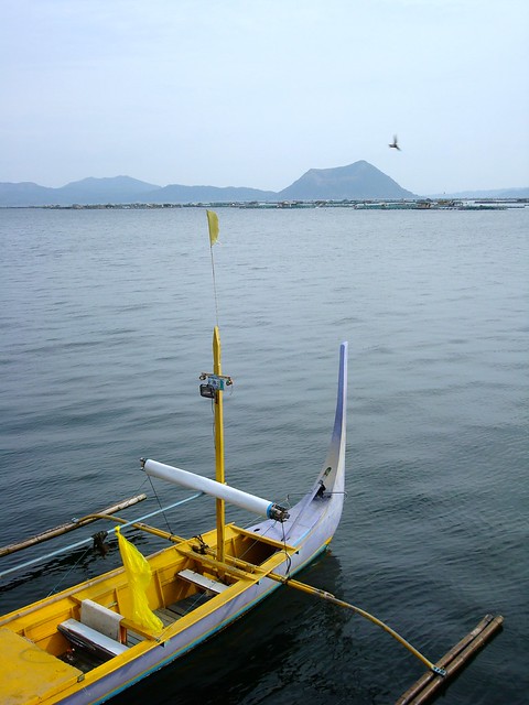
The boat knifed across the lake, sending a steady spray of water over the gunwales and drenching the two passengers huddled near the rear. Gradually, the hazy gray shape I'd seen in the distance became a landmass, and my girlfriend and I would soon reach its shore. Up ahead, at the water's edge, other small, colorful boats waited for the return of their captains like dogs leashed outside a bodega. Beyond the rickety docks, a large sign welcomed new arrivals to Taal Lake and drab single-storey buildings clustered together to form some semblance of a town. Before long, we hoped, we'd be staring down into the beating heart of this volcanic island.

What we didn't know at the time was that Taal is one of the most active volcanoes in the Philippines, and one of the most destructive. In 1911, one hundred years before our visit, a massive eruption killed more than a thousand people and caused extensive damage to surrounding areas in the province of Batangas. We had been drawn here by a geographic oddity: an island on a lake inside an island on a lake. Roughly five kilometers across, Volcano Island is essentially a collection of craters and cones created by over 30 eruptions since 1572, when Father Gaspar de San Augustin wrote "there is a volcano of fire which is wont to spit forth many and very large rocks, which are glowing and destroy the crops of the natives." The island has grown in size by 25% in the centuries since this first account, and to reach it, travelers must cross Taal Lake, a body of water that is itself a caldera, or massive crater.

For 1,500 pesos (about $35) we had been brought this far from the bus stop in Tagaytay. Upon landing, the third passenger on our boat—a native of the island's village—explained that we would need to pay several hundred pesos more to rent scrawny ponies to carry us up the side of the volcano. And that was in addition to the tourist's fee of 50 pesos per person. The young women staffing the welcome center reiterated the supposed terms of entrance to us again, but eventually gave up when we kept insisting on hiking to the top. Although my girlfriend and I knew little about the volcano's history, we were well aware that several paths led to the edge of the smaller of the two crater lakes.

Given that it was already late afternoon, we chose to follow the Daang Kastila Trail, the busiest and most direct route to the center of the island. Ticket stubs in hand, we walked back outside and proceeded up the dusty track to the summit. Moving past a small corral, we followed a train of ponies through the village where dogs, chickens, and children scrambled to get out of the way of oncoming traffic. No signs marked the trail, but it wasn't difficult to find—groups of mounted tourists trotted by regularly, busily texting friends or twisting in their saddles to snap a photo during their bumpy descent. We completed the climb in less than an hour, and fortunately managed to time our return trip with the sunset. 

As eerie as it was to feel heat radiating from beneath my boots and to catch the occasional whiff of sulfur on the breeze, I'm glad to have hiked Daang Kastila, especially when I did. According to the Philippine Institute of Volcanology and Seismology, Taal has recently experienced a series of volcanic earthquakes and the crater lake has become more acidic, even as its temperature has risen by nearly four degrees Fahrenheit. As of last week, Volcano Island was off limits to tourists. Before making your own plans to undertake a volcano hike in the Philippines, be sure to consult the Department of Tourism's website for relevant travel advisories.

Historical Maps and What They Teach Us

Because I don't enjoy shopping, I rarely buy souvenirs on my trips abroad. Yet two years ago, while browsing the stacks of a used bookstore in St. Andrews, Scotland, I happened across a small volume with a faded red cover that I couldn't bear to leave behind. Plus, £4.50 hardly seemed extravagant given that I'd paid £3.80 for a pint of beer and a mug of black coffee the night before.

Published in 1928 by Methuen & Co. Ltd. of London, The Fjords and Folk of Norway is a unique combination of travel guide, social history, and encyclopedia. It was peppered with 43 images photographed and captioned by the author Samuel J. Beckett, and to my delight, included a two-color, fold-out map of a country the preface confidently described as "a land in every way ideal for holiday travel." Given the theme for this year's Geography Awareness Week, I thought it deserved a mention here.

As readers of this blog already know, I can get a bit nerdy when it comes to maps. Even so, I'd argue that The Edinburgh Geographical Institute's precise cartography is interesting for a couple of different reasons. First of all, the scale shows distances in British Statue Miles, Kilometres, and Norwegian Miles—a unit of measure I wasn't familiar with. Secondly, the large scale inset of the great fjord region offers an informative lesson in how physical geography and population density determine transportation infrastructure. By studying the railway, road, and steamboat routes, it's possible to accurately infer that the landscape is rugged and sparsely peopled. In fact, about two-thirds of Norway is mountainous and in 1925, the population was only 2,772,414. Today this Scandinavian nation has about 4.6 million citizens, many of whom still rely on boats as a swift means of North-South travel.

Finally, I found it somewhat curious that the mapmakers also included an inset of historic Bergen, gateway to the fjord region. Lacking enough detail to be useful for visitors, it's informative nonetheless, with elevations for a few of the surrounding mountains and an attempt to indicate the growth of the city beyond its commercial center.

In Praise of Global Knowledge

Have you hugged a map lately? If not, consider doing something to show your appreciation for maps and atlases between the 15th and the 21st of November. Why, you ask? Because the third week of the month is Geography Awareness Week, an annual event observed by a growing number of students, teachers, parents, and professionals. GAW was created in 1987 to inspire kids to learn more about the distribution of and spatial relationships between people, places, and environments on Earth, but anyone can take part in this celebration of geography—it's not exclusionary.

If this all comes as news to you and you haven't the slightest clue about where to begin, stop wringing your hands and head on over to National Geographic's My Wonderful World Blog. They've already posted a "quasi-definitive list" of fun ideas for gamers, cooks, armchair travelers, and yes, bloggers too. Problem solved.

I'll undoubtedly be writing about maps myself, but I'm also planning to introduce Captain Cartography (pictured) to a few educators here in Brooklyn. With some luck, my comic book will be available in time for Geography Awareness Week 2010.
Art by Dezi Sienty